A road trip through Northern Patagonia is where fjords, volcanoes, and untouched forests await at every turn. The journey from Puerto Montt to Hornopirén is short in distance, but it is overflowing with natural beauty and adventure. This route offers a perfect introduction to Chile’s famous Carretera Austral.
With a car rental at El Tepual International Airport in Puerto Montt, you can set your own pace and fully appreciate this scenic drive in Chile. This Hornopirén road trip is for travellers who love nature. You can explore and stop for photos or short hikes whenever something catches your eye.
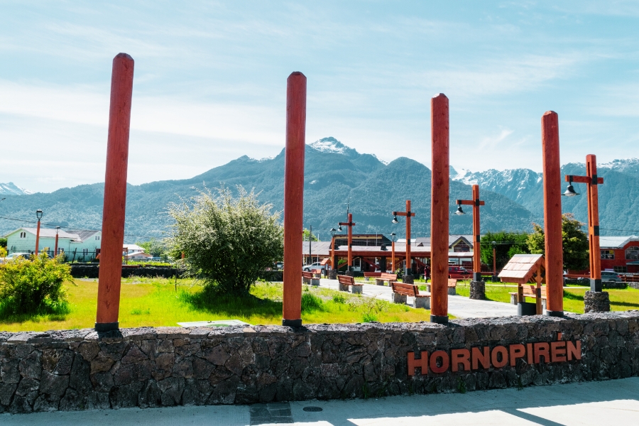
Hornopirén is a small Patagonian town located in Chile’s Los Lagos Region. It is located about 110 kilometres south of Puerto Montt on the shores of the Comau Fjord. It serves as the capital of the Hualaihué commune in Palena Province.
Hornopirén is framed by fjords, dense temperate rainforest, and towering volcanoes. To the east rise steep green slopes and volcanic peaks such as Hornopirén Volcano and the striking Volcán Yate, while to the west the fjord opens towards the Pacific. The name “Hornopirén” comes from the Mapuche language and means “Snow Oven”, a nod to the snow-capped peaks that dominate the skyline.
Hornopirén sits beside major protected areas, including Hornopirén National Park and Pumalín Park. These reserves offer access to ancient forests, hiking trails, lakes, and wildlife. Boat trips through fjords and excursions to natural hot springs are also popular activities.
Driving from Puerto Montt to Hornopirén is not just a transfer, but a scenic Patagonian journey in its own right. While the distance looks short on a map, fjords, mountains, and ferries shape how long the trip actually takes.
Hornopirén is about 110 kilometres south of Puerto Montt in a straight line, but the real travel distance depends on the route you choose. The most common option follows the Carretera Austral (Route 7) and includes a ferry across the Reloncaví Sound. This route involves 50 kilometres of driving, a 30-minute ferry crossing, and then another 55 kilometres to Hornopirén, taking around 3.5 to 4 hours in total.
If you prefer to avoid ferries, you can take the inland route via Cochamó and Río Puelo, which is about 230 kilometres long. This alternative usually takes 5 to 6 hours due to winding mountain roads.
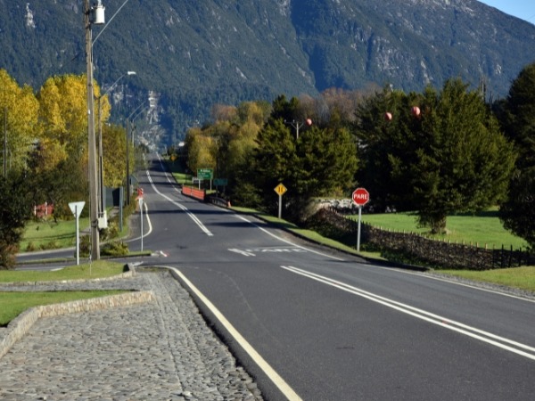
Leaving Puerto Montt, roads are paved and easy to drive. Beyond the city, conditions become more rural, with sections of gravel, narrow lanes, and sharp curves. These roads are manageable with a normal car, but drive slowly and cautiously. Traffic is light, mostly locals, pickup trucks, and a few travellers.
The La Arena to Puelche ferry runs frequently in high season and is well organised, though queues can form at midday. The crossing itself is calm and scenic, with views of fjords, seabirds, and forested hills.
The drive offers classic Patagonia landscapes. Expect fjords, rivers, waterfalls, dense temperate rainforest, and volcano views, especially Volcán Yate and Hornopirén Volcano on clear days. Fuel stations are limited, so fill up in Puerto Montt or Puerto Varas.
Northern Patagonia has a temperate maritime climate, meaning mild temperatures but frequent rain and rapidly changing conditions. Below is a clear seasonal breakdown to help you choose the best time to go.
Summer is the most popular and the easiest time for this road trip. Daytime temperatures usually sit between 15 and 20°C, which is cool but comfortable for driving, hiking, and ferry crossings. Rainfall is lower than in other seasons, although short showers are still common.
The biggest advantage is daylight. Around the December solstice, you get over 15 hours of light. Services are fully operating, ferries run frequently, and accommodation options are at their widest. The landscape is at its greenest, with wildflowers lining the roads and volcanoes occasionally revealing themselves on clear days.
Spring and autumn offer the best balance between scenery and solitude. October and November bring rushing waterfalls from snowmelt, fresh greenery, and very few travellers. Temperatures are cooler and rain is more frequent. March and early April are relatively mild, with quieter roads and a calm, reflective atmosphere as summer crowds fade. Expect shorter days and more variable weather, but also fewer ferry queues and easier last-minute bookings.
Winter is the most challenging but also the most atmospheric season. Expect cold temperatures, frequent rain, occasional snow at higher elevations, and much shorter daylight hours. Some accommodations and restaurants close, and ferry schedules are reduced. However, snow-capped volcanoes, powerful waterfalls, and misty fjords create striking scenery. Winter suits experienced, flexible travellers who are comfortable driving in wet conditions and do not mind slower pacing.
The drive from Puerto Montt to Hornopirén can be broken into scenic segments. Below is a step-by-step breakdown following the scenic overland route via Cochamó and Río Puelo. This avoids the ferry for road exploration.
The journey officially begins in Puerto Montt, a bustling port city. As you leave the outskirts, follow signs for Route 5 or Route 7 towards Puerto Varas, Ensenada, or Cochamó. Within minutes, traffic thins and rolling countryside appears. If you choose the inland route via Puerto Varas, you briefly skirt Lago Llanquihue before turning south-east toward Ensenada. This first stretch is relaxed and scenic, with paved roads, grazing cattle, and distant volcanoes.
After roughly an hour, you reach Ensenada and begin heading south along the edge of the Reloncaví Estuary. From here, the road curves around the head of the fjord, threading through dense forests and quiet valleys. Watch for signs to Ralún, a tiny fishing settlement at the fjord’s innermost point. A short stop here is worthwhile. The small pier, surrounding wetlands, and forested slopes is a peaceful scene, and you may see fishermen tending boats or nets.
Beyond Ralún, the road crosses a bridge and continues southwest along the eastern shore of Reloncaví Sound, entering the Cochamó commune. The scenery becomes more dramatic, with steep mountains rising almost straight out of the fjord.
Soon, you arrive near Cochamó, a small rural town tucked into a striking valley. A short detour brings you into the village, where a wooden church, local shops, and riverside views await. It is surrounded by granite walls and lush hills.
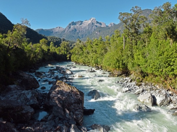
Continuing south from Cochamó, the drive gradually unfolds into one of the most scenic river corridors in Chile as the route follows the Río Puelo. For 35 kilometres, the road runs alongside this striking river, whose jade-green waters originate in alpine lakes across the Argentine border before flowing into the Reloncaví fjord.
At times, the river appears calm and glassy, while in other stretches it rushes over rocks. Towering above the valley, layered mountain ridges create a backdrop. On clear days, Volcán Yate dominates the scene, its snow-capped pyramid rising sharply to the east.
The road winds through quiet farmland and tiny rural settlements such as Pueblo Hundido or Paso El León. Eventually, you reach the village of Río Puelo, located near the point where the river widens toward its estuary. Green pastures surround the area, and you masy see gauchos on horseback tending cattle along the roadside. While a detour east leads to the Tagua Tagua Lake, staying on course toward Hornopirén means continuing southwest.
Beyond Puelo, the landscape shifts again as the road approaches the coast. The air often carries a hint of salt, and the terrain rises and falls over low ridges before descending toward small seaside communities. Villages such as Contao offer a pleasant pause, with bay views and the occasional roadside stand selling empanadas or smoked fish. This stretch rewards attentive drivers with waterfalls, fern-covered cliffs, and panoramic viewpoints overlooking rivers and fjords.
By the time the road reconnects with the final route toward Hornopirén, the sense of remoteness is complete. Long stretches pass without another vehicle, and Patagonia’s wilderness is fully present.
The final leg from the Río Puelo area to Hornopirén is where fjords, forests, and volcanoes come together. At this point, the route rejoins Route 7, the Carretera Austral, and follows the eastern edge of the Comau Fjord for 40 to 50 kilometres. Road conditions are generally good, with a mix of paved sections and well-maintained gravel. The rounded silhouette of Hornopirén Volcano may appear ahead.
As the road traces the fjord, the scenery constantly shifts. One moment you are driving beside calm water dotted with mussel farms, their floating buoys forming long lines across the fjord, and the next you are climbing through dense native forest. Locals can often be seen harvesting shellfish along small coves at low tide. The road frequently hugs the shoreline before winding inland past towering ferns and coigüe trees.
This stretch is also known for its hidden hot springs. Signs for places like Termas del Sol point toward forested side roads leading to natural geothermal pools. Some reach temperatures above 40°C. As Hornopirén approaches, houses and small farms appear, and the road straightens. The town is located around a bend, centred near the waterfront. You’ll also see colourful wooden buildings, a quiet plaza, fishing boats at the pier, and steep green slopes rising behind the town.
Hornopirén National Park (Parque Nacional Hornopirén) is the natural heart of the Hualaihué region and one of northern Patagonia’s most rewarding wilderness areas. Covering roughly 482 square kilometres, the park protects a dramatic landscape of mountains, glaciers, lakes, rivers, and ancient temperate rainforest.
The landscapes inside Hornopirén National Park are varied. Elevations rise from near sea level to over 1,500 metres, creating deep valleys, steep ridges, and glacier-carved basins. Although the volcanoes Hornopirén and Yate sit just outside the official park boundaries, they loom constantly in the background and shape the park’s character. Around 30 square kilometres of glaciers feed rivers and lakes throughout the area, giving the water its distinctive turquoise and milky-blue tones.
Dense Valdivian temperate rainforest blankets much of the park. Among its most extraordinary features are the ancient alerce trees, some over a thousand years old and reaching heights of 50 to 60 metres. Walking beneath them feels like entering a living cathedral.
The forest is lush and layered, with coigüe, ulmo, arrayán, ferns, mosses, and giant nalca leaves creating a thick green world broken only by streams and waterfalls. Lakes such as Lago Pinto Concha, Lago Cabrera, and Lago Inexplorado punctuate the mountains, which are open spaces amid the dense forest.
Hornopirén National Park is accessed via a gravel road roughly 17 kilometres northeast of Hornopirén town. There are no roads inside the park, and infrastructure is minimal. Visitors should expect basic trailheads, limited signage, and no visitor centre or shops. Proper footwear, rain gear, food, and water are essential, as weather can change quickly and trails are often muddy even in summer.
The Lago Pinto Concha Trail is the park’s flagship hike and one of the most memorable treks in northern Patagonia. The route is approximately 10 kilometres one way, climbing steadily through old-growth forest. The trail is well-marked but physically demanding, with muddy sections, roots, and small stream crossings. Most hikers take 3 to 4 hours to reach the lake.
Lago Pinto Concha is in a broad alpine basin with volcanic sand beaches, crystal-clear water, and sweeping mountain views. Snow patches and small glaciers are often visible on surrounding peaks, and the southern slopes of Volcán Yate dominate the horizon. In summer, designated camping areas allow overnight stays.
For a shorter and more accessible outing, the Cascadas Río Blanco Trail is a great introduction to the park’s landscapes. This trail is 4.5 kilometres one way and follows the vivid turquoise Río Blanco. Access begins on private land, where a small entrance fee is typically paid before reaching the park boundary.
After about an hour of walking, the sound of rushing water announces the waterfalls ahead. Two cascades plunge into a deep blue pool, surrounded by dense forest and moss-covered rock walls. Wooden steps and platforms allow close viewing, where the spray and sound create an immersive experience. The hike is considered easy to moderate and takes around 3 hours round trip.
Wildlife in Hornopirén National Park is subtle but rewarding for patient observers. Mammals such as pudú deer, foxes, and even pumas inhabit the forest, though sightings are rare. Birds are more commonly encountered, with over 120 recorded species. The Magellanic woodpecker, with its striking black body and red head, is one of the park’s highlights. You'll hear from shy forest birds like the chucao tapaculo and huet-huet. Near rivers and lakes, kingfishers and waterfowl are frequently spotted.
The journey from Puerto Montt to Hornopirén is one of those scenic drives in Chile where the landscape keeps changing, from fjord-lined roads to forested valleys beneath volcanoes. By the time you reach the trails and lakes of Hornopirén National Park, the slower pace feels natural, shaped by ferry crossings, gravel roads, and long views over water and mountains.
Rent a car in Puerto Montt with Final Rentals to easily explore fjords and forested valleys, the park's trailheads. With Final Rentals, booking a car online is fast and simple. Select El Tepual International Airport as your pickup location, enter your travel dates, and choose a vehicle for your trip. Book and manage your car rental at any time. Download the Final Rentals app on Google Play and the App Store.